Red Cliffs Lodge is a fairly new place on the Colorado
River used by Trafalgar. This was our
view from our breakfast table the morning we left.
After leaving Moab and a number of miles down the road,
we came upon Wilson Arch. It sits right
next to the roadway and it was not necessary to hike to see the arch. We spent several minutes looking and taking
pictures of the arch and then were again on our way. We say goodbye to the Moab area and Arches
National Park.
We travel along Rte 191 and have some nice views of the
countryside.
Yet the landscape and scenery does not match the dramatic
views we have come to enjoy.
Just before Cortez, there was a large field with many old vehicles in
it. I only got a quick picture and only
captured a couple of the cars instead of the section that had many cars. A few miles later, we arrived in Cortez and after a short break turn onto Rte 160 east and head to Mesa Verde.
Entering Mesa Verde, we traveled up the mesa rising over
1,000 feet in a very short amount of time and distance. The road switches back and forth up the side
of the mesa and you can see for miles.
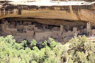
We arrive at Cliff Palace.
Now we did not go down to the Cliff Palace this time, but
we did walk around the parking area and trail seeing the valley head away from
us. Imagine this as your front yard!
Next, we headed to Spruce Tree House. We first had lunch before visiting the ruins. And guess what? On the way to the Spruce Tree House overlook,
I see another lizard, this one with stripes.
We get to the Spruce Tree House overlook, trail head, and
before we head down, took a wide angle view of the structure.
You cannot go into the buildings because they have them
roped off, but you can get fairly close to them.
There is one Kiva (reconstructed, I think) that they allow you to go down into and
see the inside. The entrance is very
narrow and you have to stay close to the ladder as you climb down. The sun was almost directly overhead
when I went inside and there was a shaft of sun coming down the entrance hole,
very cool. The picture is almost as nice as being there.
As we were finishing our hike back up the trail from
Spruce Tree House, Carmen posed at the overlook. Gorgeous! Yea, the ruins also.
Continuing to Kayenta, we pass a couple of wayward lovers
on opposite sides of the fence, but that wasn’t going to stop them!
We drove by the four corners area. This is where Arizona, New Mexico, Colorado,
and Utah meet and form a quadripoint. It
is the only place in the U.S. where four states meet. We did not stop, but I do have a picture (not mine).
In the distance we can see Ship Rock, a point used for
both the Native Americans and the Anglo Americans moving west in wagon trains.
Driving along we pass butte formations suggesting the
visions we will have when we get to Monument Valley.
As we get close to Kayenta our day’s
ride nears its end. We drive into Arizona with a sign reading Ya’ at eeh
Dine Bik’ evah (or “welcome to the Navajo Nation”) and of course more desert and
high mesas.
Tomorrow, we go to Monument Valley and end the day at the Grand Canyon. Later, Bob and Carmen.


No comments:
Post a Comment